
Thur Mountain [An Tor]
Good walks are even better shared.
Overview
Thur Mountain [An Tor]
Thur Mountain, locally known as An Tor, is a prominent feature in the Scottish Highlands, standing proudly at 825 meters. Known as a Marilyn, it offers a moderately challenging climb that rewards hikers with stunning views. Whether you’re a seasoned hiker or someone who has recently decided that Netflix is not the best mountain in life, Thur Mountain is an excellent choice for all!
Geology
This majestic mountain is primarily made up of schist and granite. The geological formations speak volumes about Scotland’s history, giving those with a keen eye a perfect opportunity to ponder the Earth’s ancient past—while also trying not to trip over a rock.
Routes
The Thur Mountain Circular route is the most popular trail, covering approximately 7.5 km. With an estimated duration of about 2.5 hours, this moderately challenging hike is suitable for those with a reasonable level of fitness. The path winds through beautiful, grassy slopes and offers the occasional rocky challenge to keep things exciting.
Summit Features
As you reach the summit, you will notice a sturdy trig point alongside a charming stone cairn. Both markers not only serve as excellent photo opportunities but also as a testament to your achievements—because who doesn’t want a selfie at the top of a mountain?
Terrain Type
Prepare for a delightful mix of rocky and grassy terrain—perfect for those hikers with an adventurous spirit! Just watch out for the boggy patches that could catch you off guard. You might feel like you’ve stepped into a scene from a nature documentary!
Views
The views from the summit are nothing short of breathtaking. Look out to Ben More and Stob Binnein, and don’t forget about the stunning vistas of Loch Awe. The best times to appreciate these sights are during late spring to early autumn, when the landscape is alive with colour and the weather is usually kinder.
Hazards
While the hiking experience is generally pleasant, always be alert for sudden weather changes in the Highlands. Conditions can shift faster than you can say 'sudden rain shower', so pack appropriately! Also, keep an eye on your footing, especially in rocky areas and those tempting yet treacherous bogs.
Access
Located conveniently near the A85, parking can be found at the nearest car park, with a park capacity for 6-8 cars. Note that public transport is limited—might want to consider assembling your best hiking buddies for a little road trip! Crianlarich is the nearest town, with some lovely cafes for a pre-hike or post-hike treat!
Facilities
While on the mountain itself, you may not find restrooms or cafes, Crianlarich does provide some essential facilities that could save the day. Think coffee, snacks, and a throne to sit on. What more can anyone ask for?
History
The name 'An Tor', translating to 'The Tower', hints at its striking height and presence among the hills. The area carries significant cultural importance, with countless stories woven into the Highland folklore, enriching your hike with a sense of history.
So, grab your gear, lace up those boots, and embark on an adventure that will leave you with memories—and hopefully not too many bruises—of your escapades on Thur Mountain!
Happy hiking!
Explore routes near Thur Mountain [An Tor]
Public walks starting within 80 km of this hill. Nearby does not mean a route reaches the summit; check its map and access before setting out.
Route planning notes
These notes describe possible approaches, not verified navigable routes or permission to cross land. Check current paths, local access rules and conditions before setting out.
Thur Mountain Circular
A scenic circular route starting from the small car park near the base, winding through grassy slopes and rocky outcrops.
Make a day of it, together
Find someone to share the walk with, or organise a day out along a route you like.
Hill facts and local notes
Classifications
Elevation
432m
1,417 ft
Prominence
218m
Coordinates
54.3124, -8.0315
G980404
OS Map
17
At the Summit
At the summit, hikers are greeted by a prominent trig point and a well-constructed stone cairn, perfect for a photoshoot to prove you made it to the top!
Terrain & Geology
Primarily composed of schist and granite, Thur Mountain offers intriguing glimpses into Scotland's geological history. The rock formations showcase the forces of nature that have shaped this rugged landscape over millennia.
Views & Scenery
Panoramic views of the surrounding peaks, including Ben More and the rolling hills of the Trossachs, along with stunning vistas of Loch Awe.
History & Heritage
Name Origin
The name 'An Tor' translates to 'The Tower' in Gaelic, possibly due to its towering stature among the surrounding hills.
Historical Significance
Historically, this area has been a favourite among those seeking to connect with nature, as well as for its rich local folklore.
Getting There & Facilities
Check current local access restrictions, parking rules and transport timetables before travelling. These notes do not confirm public access to the summit.
Parking
The nearest car park is located off the A85 at grid reference G980404, with space for about 6-8 cars.
Public Transport
Limited public transport options; the nearest bus service operates between Crianlarich and Oban, with a short taxi ride to the trailhead.
Nearby Facilities
While there are no facilities on the mountain, Crianlarich offers some cafes and public toilets — perfect if you need to fuel up before your ascent.
Safety Information
Known Hazards
- Beware of sudden changes in weather, as conditions can shift from sunny to stormy in the blink of an eye. Also, be cautious of loose rocks and the occasional boggy patch!
General Safety Tips
- Check weather conditions before setting out
- Carry appropriate clothing and equipment
- Let someone know your planned route
- Take a map, compass, and GPS device
- Carry emergency supplies: food, water, first aid kit, torch
Hills
Some common questions about the hills answered
Are there group walks up Thur Mountain [An Tor]?
Many walkers use Walkmates to join or organise walks with others. You can check for group walks around Thur Mountain [An Tor] through the maps
Are there other walkers around Thur Mountain [An Tor]?
Activity varies by location and time, but Walkmates lets you see whether others have shared walks or shown interest in this area. Find other people through the walking friends search walking friends for Thur Mountain [An Tor] search or of course create your own walk for Thur Mountain [An Tor]
Can I organise a walk to Thur Mountain [An Tor]?
Yes. If there aren’t any walks listed already, you can create a walk and make it available for others to join.
If you're signed up to Walkmates, you can create a walk to Thur Mountain [An Tor].
How do I find a walk up this hill?
There are often multiple ways to walk this hill, depending on experience and route preference. Walkmates helps you explore walks and routes that others have shared.
Can I suggest a new route up Thur Mountain [An Tor]?
Yes. You can suggest or create routes to share with others. Walkmates focuses on the social side of walking, so routes are used to help people organise walks and explore areas together, rather than as detailed navigation tools or route libraries.
Other uses really appreciate knowledgeable walkers sharing their routes. Share your favourite route to Thur Mountain [An Tor] here
The is an error or something incorrect about this hill. How do I let you know?
We always strive to keep the information on Walkmates as accurate as possible. If you find an error, please let us know through the contact form and we'll aim to correct it as quickly as possible
Community Discussion
Comments
Location
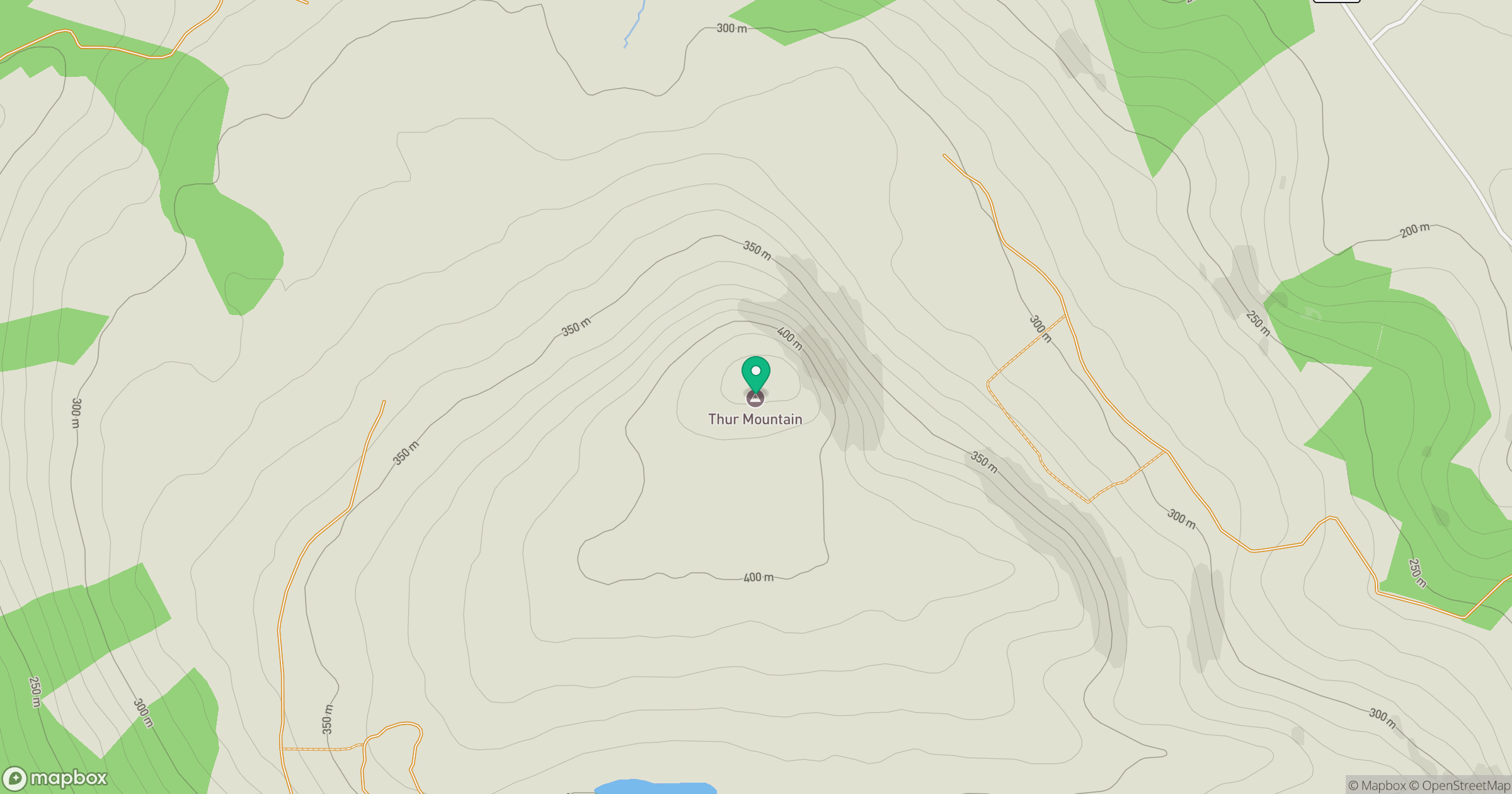
Grid reference: G980404
View on OpenStreetMapOpens a map in a new tab, centred on the hill.
Hills within 30 km
Straight-line distance, not a walking route or confirmation of access.
No comments yet. Be the first.